the evolution of the garden city plan of the marino estate, dublin
by fmgarchitects.
The following text was written for a National Heritage Week exhibition in the Marino Casino of the “Marino Housing Estate from Conception to Modern Times” for the 2024 100 year centenary events that marked the development of the estate.
 Marino Perspective Drawing by Raymond Unwin 1914
The design and layout of the Marino estate went through a number of iterations prior to the version of the estate that we know today. The earlier layout were quite different but featured Garden City layout concepts that were carried into the final design. The British town planners, Raymond Unwin and Patrick Geddes were brought to Dublin in 1914 by the Civics Institute of Ireland, a voluntary body engaged in raising consciousness of modern concepts. They became interested in the Marino project, and Unwin prepared an initial plan and detailed drawing for the scheme.
The suggested Marino plan that features in the 1918 Dublin Corporation Report of the Housing Committee by the city architects developed Unwin’s plan and features terraced housing blocks laid out in a geometric pattern with enclosed rear private open space and set-back gardens to the front of the houses. A semi-circular crescent at the southern end of the site at Marino Mart mirrors the 18th century Marino Crescent on the opposite side of the Malahide Road. The current line of Griffith Avenue did not feature and a second crescent which responds to the O’Brien Institute and the Casino closes the northern side of the Marino scheme punctuated by a north-easterly axial route the appears to frame a view of the historic buildings to the north. A number of axial routes are set up through the estate which intersect formal open space and circular features. The drawing appears to feature only an initial eastern phase of the final overall site with an incomplete north-south primary road terminated by the southern crescent at Fairview indicated.
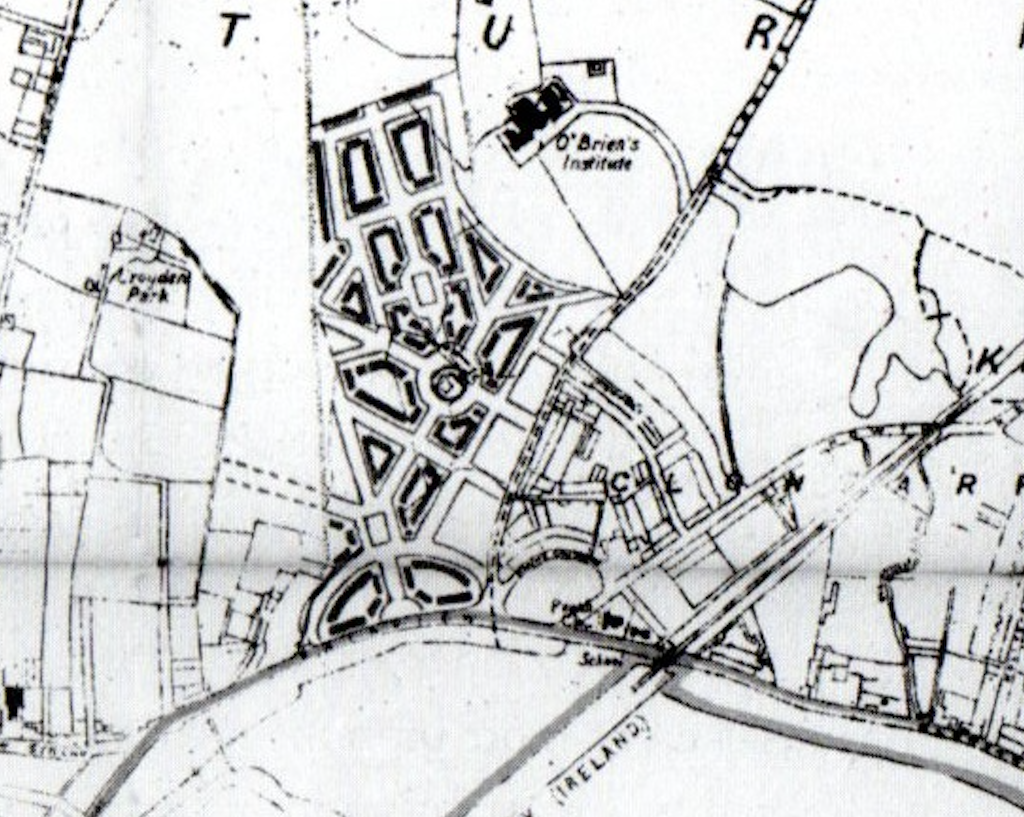 Suggested Marino plan from the 1918 Dublin Corporation Report of the Housing Committee
A more developed and formal design for the eastern part of the site was produced by the City Architects Office in 1919 centred around a monumental elongated geometric civic space fronted and ringed by terraced houses and comprising of a “botanic parterre” and a square-planned children’s playground interspersed with civic buildings including a public assembly house terminating the northern end of the space. Other civic facilities including a church, school building and shops are located within the scheme. The plan includes features of the final design including terraced housing blocks and curving roads criss-crossed by axial routes that are punctuated by canted crossroad nodes and geometric open spaces. The commercial frontage along Fairview/Marino Mart and the current site of the St. Vincent de Paul church and schools were planned for housing at the time. The final alignment for Griffith Avenue was set out on the plan marked as a “future main road”. At the time, no housing frontage was proposed to the west side of the Malahide Road which was marked as “existing plantation”.
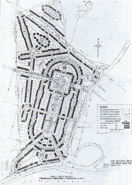
Dublin Corporation City Architects’ design for the Marino Estate 1919
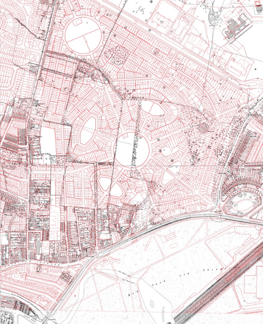
The final version of the Marino plan resulted in the civic and commercial facilities that were interspersed within the housing scheme being decanted to edges along Marino Mart and Griffith Avenue and the geometric open space elements being more evenly dispersed within the site along the principal axes of Brian Road and Croydon Park Avenue/Marino Park Avenue. The overlay below illustrates the current layout of the estate (red) in relation to the 19th century Ordnance Survey prior to its development. The original location of Marino House can be identified at the corner of Brian Road and St. Aidan’s Park Avenue as well as the original location of the avenue at Griffin Gates at Marino Mart, Fairview.
No comments on ‘the evolution of the garden city plan of the marino estate, dublin’
Leave a Reply